Sentinel-2 Level-2A Surface Reflectance Collection 1
Date modified: 08 April 2025
Product overview
Background
The Sentinel-2 mission is part of the European Union Copernicus programme for Earth observations. Sentinel-2 consists of twin satellites, Sentinel-2A (launched 23 June 2015) and Sentinel-2B (launched 7 March 2017). The two satellites have the same orbit, but 180° apart for optimal coverage and data delivery. Their combined data is used in the Digital Earth Arabia Sentinel-2 product.
Together, they cover all Earth’s land surfaces, large islands, inland and coastal waters every 3-5 days.
Sentinel-2 data is tiered by level of pre-processing. Level-0, Level-1A and Level-1B data contain raw data from the satellites, with little to no pre-processing. Level-1C data is surface reflectance measured at the top of the atmosphere. This is processed using the Sen2Cor algorithm to give Level-2A, the bottom-of-atmosphere reflectance (Obregón et al, 2019). Level-2A data is the most ideal for research activities as it allows further analysis without applying additional atmospheric corrections.
Digital Earth Arabia Sentinel-2 Level-2A Surface Reflectance Collection 1 is the Sentinel-2 product processed for enhanced calibration and consistent time series between Sentinel-2A and Sentinel-2B. Digital Earth Arabia does not host any lower-level Sentinel-2 data.
A `Jupyter Notebook <>`__ which demonstrates loading and using this dataset in the Sandbox is also available.
Specifications
Table 1: Sentinel-2 Level-2A Collection 1 product specifications
Specification |
|
|---|---|
Product name |
Sentinel-2 Level-2A Collection 1 |
Number of bands |
17 |
Cell size - X (metres) |
10, 20, 60 (band-dependent, see Table 2) |
Cell size - Y (metres) |
10, 20, 60 (band-dependent, see Table 2) |
Coordinate reference system |
EPSG: 6933 |
Temporal resolution |
Every 5 days |
Temporal range |
2017-01-01 – present |
Parent dataset |
Sentinel-2 Level-1C |
Update frequency |
Daily |
Figure 1: Sentinel-2 Level-2A Collection 1 geographic extent
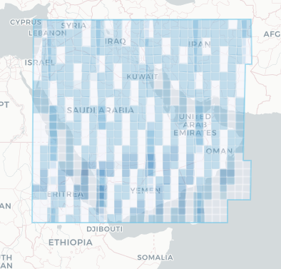
Digital Earth Arabia Sentinel-2 Collection 1 data is available for the regions shaded in blue. Specific temporal and geographic extents can be explored as an interactive map on the Digital Earth Arabia Metadata Explorer.
Table 2: Sentinel-2 Level-2A Collection 1 measurements
Band ID |
Description |
Spatial resolution (m) |
Value range |
Data type |
No data value |
|---|---|---|---|---|---|
B01 |
Coastal aerosol |
60 |
|
|
|
B02 |
Blue |
10 |
|
|
|
B03 |
Green |
10 |
|
|
|
B04 |
Red |
10 |
|
|
|
B05 |
Red edge 1 |
20 |
|
|
|
B06 |
Red edge 2 |
20 |
|
|
|
B07 |
Red edge 3 |
20 |
|
|
|
B08 |
Near infrared (NIR) 1 |
10 |
|
|
|
B8A |
NIR 2 |
20 |
|
|
|
B09 |
Water vapour |
60 |
|
|
|
B11 |
Short-wave infrared (SWIR) 1 |
20 |
|
|
|
B12 |
SWIR 2 |
20 |
|
|
|
AOT |
Aerosol optical thickness |
20 |
|
|
|
WVP |
Scene average water vapour |
20 |
|
|
|
SCL |
Scene classification layer |
20 |
|
|
|
CLOUD |
Cloud Probabilities |
20 |
|
|
|
SNOW |
Snow Probabilitie |
20 |
|
|
|
The Digital Earth Arabia Sentinel-2 Level-2A Collection 1 dataset has seventeen bands of data, which can be grouped into the multispectral bands, and the auxilary quality assurance bands.
Multispectral observations - 12 bands: Sentinel-2 satellites carry a multispectral instrument that measures in the visible, near infrared, and short-wave infrared ranges. These are indexed as
B01 - B12. The band B10 is not included in the DE Arabia Sentinel-2 Level-2A product as it does not contain surface information.Surface reflectance values are scaled between
1and10000. Note different spectral bands have different native resolutions.Quality assurance - 3 bands: The Sentinel-2 Level-2A Collection 1 product also includes three auxilary data bands which are used to improve the accuracy of surface reflectance-derived products. These corrections were applied as part of the Sen2Cor conversion from Level-1C (top-of-atmosphere) to Level-2A (bottom-of-atmosphere) data.
Scene Classification Layer (
SCL) distinguishes between cloudy, clear and water pixels. The algorithm identifies areas as clouds, snow, cloud shadows, vegetation, bare soil and water. The resulting SCL is used for cirrus cloud correction in the processing chain. It is also commonly applied in further analysis as a cloud mask, which removes unwanted cloudy pixels from the multispectral observations. SCL bit values are defined in Table 3.Aerosol Optical Thickness (
AOT) is a measure of haze, or visibility through the atmosphere. In Sentinel-2 Level-2A data, this is derived using the Dark Dense Vegetation pixel method, which relies on calibrating reflectance against dark vegetation and using the estimated atmospheric thickness to correct the rest of the measurements.Water Vapour (
WVP), also referred to in literature as Integrated Water Vapour (IWV) or Water Vapour (WV), is the total water vapour integrated over an atmospheric column. It is calculated using an atmospheric pre-corrected differential absorption algorithm (Schläpfer et al, 1998). Like AOT, it is a key component of atmospheric correction.
Table 3: SCL bit values
Bit value |
Classification |
|---|---|
0 |
No data |
1 |
Saturated or defective |
2 |
Dark area pixels |
3 |
Cloud shadows |
4 |
Vegetation |
5 |
Bare soils |
6 |
Water |
7 |
Unclassified |
8 |
Cloud medium probability |
9 |
Cloud high probability |
10 |
Thin cirrus |
11 |
Snow or ice |
Sentinel-2 Level-2A Collection 1 metadata can also be viewed on Digital Earth Arabia’s Metadata Explorer.
Processing
The Copernicus Sentinel-2 Collection-1 is currently being generated using the Sentinel-2 historical archive to ensure consistent time series from Sentinel-2A and Sentinel-2B, with uniform processing baselines and enhanced calibration. This process particularly focuses on improving the geometric performance of the products and their radiometry.
More details on Sentinel-2 Level-2A Collection 1 processing can be found in Collection-1 Processing Baseline
Media and example images
Image 1: Riyadh Region, Saudi Arabia (20.3°N, 45.5°E), 26 Nov 2022 (RGB).
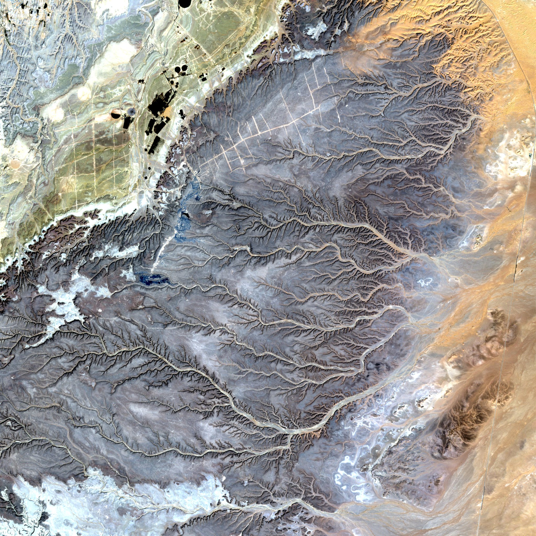
Credit: Copernicus Sentinel data / ESA
Image 2: Agriculture in Saudi Arabia. 2015 Sentinel-2, false-colour.
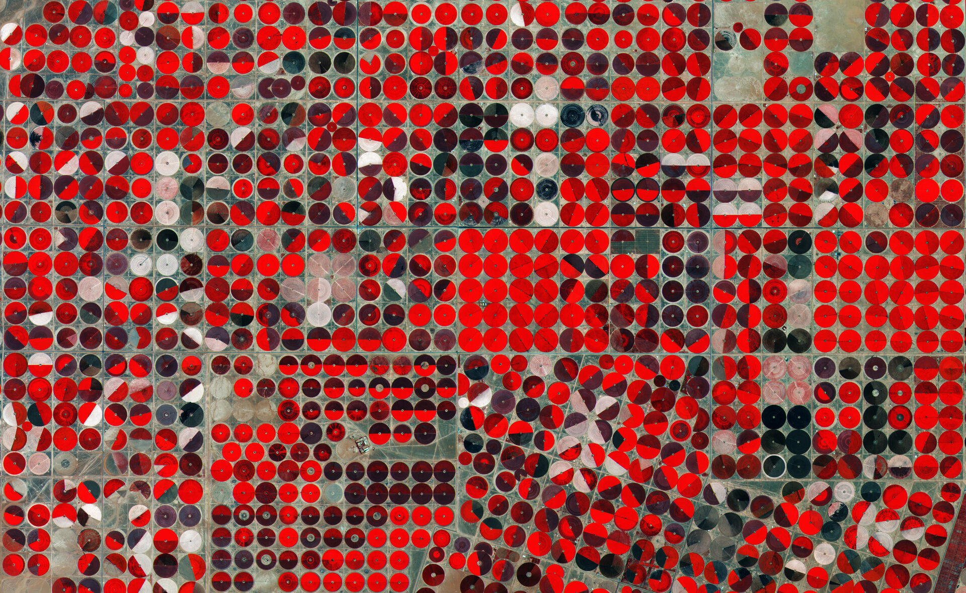
Credit: Copernicus Sentinel data / ESA
References
Obregón, M.A., Rodrigues, G., Costa, M.J., et al. (2019). Validation of ESA Sentinel-2 L2A aerosol optical thickness and columnar water vapour during 2017-2018. Remote Sensing, 11(14), 1649. https://doi.org/10.3390/rs11141649
Schläpfer, D., Borel, C.C., Keller, J., et al. (1998). Atmospheric precorrected differential absorption technique to retrieve columnar water vapor. Remote Sensing of Environment, 65(3), 353-366. https://doi.org/10.1016/S0034-4257(98)00044-3.
Gascon F., Bouzinac C., Thépaut O., et al. (2017). Copernicus Sentinel-2A calibration and products validation status. Remote Sensing, 9(6), 584. https://doi.org/10.3390/rs9060584
License
Access to Sentinel data is free, full and open for the broad Regional, National, European and International user community. View Terms and Conditions.
Acknowledgements
The Sentinel-2 Level-2A Collection 1 product is provided by the European Space Agency.
Data access
Amazon Web Services S3
Sentinel-2 Level-2A C1 is available in AWS S3, sponsored by the Public Dataset Program.
Table 4: AWS data access details
AWS S3 details |
|
|---|---|
Bucket ARN |
|
Product name |
|
The bucket is in the AWS region eu-central-1. Additional region specifications can be applied as follows:
aws s3 ls --request-payer requester s3://sentinel-s2-l1c/
The data is organised per tiles using Military Grid Reference System. The file paths follow the format
<utm_zone>/<latitude_band>/<grid_square>/<year>/<month>/<scene_ID>.
Table 5: AWS file path convention
File path element |
Description |
Example |
|---|---|---|
|
Grid zone designator |
|
|
Latitude band are lettered C- X, omitting the letters “I” and “O” |
|
|
Pair of letters designating one of the 100,000-meter side grid squares inside the grid zone |
|
|
Year the data was collected, |
|
|
Month of the year the data was collected (without leading zeros) |
|
|
All files corresponding to a scene |
|
OGC Web Services (OWS)
This product is available through DE Arabia’s OWS.
Table 6: OWS data access details
OWS details |
|
|---|---|
Name |
|
Web Map Services (WMS) URL |
|
Web Coverage Service (WCS) URL |
|
Layer name |
|
Digital Earth Arabia OWS details can be found at `# <>`__.
Open Data Cube (ODC)
The Sentinel-2 Level-2A Collection 1 dataset can be accessed through the Digital Earth Arabia ODC API, which is available through the `Digital Earth Arabia Sandbox <>`__.
ODC product name: sentinel_2_l2a
Specific bands of data can be called by using either the default names or any of a band’s alternative names, as listed in the table below. ODC datacube.Datacube.load commands without specified bands will load all bands; see ODC documentation.
Table 7: Sentinel-2 ODC band names
Band name |
Alternative names |
|---|---|
B01 |
band_01, coastal_aerosol |
B02 |
band_02, blue |
B03 |
band_03, green |
B04 |
band_04, red |
B05 |
band_05, red_edge_1 |
B06 |
band_06, red_edge_2 |
B07 |
band_07, red_edge_3 |
B08 |
band_08, nir, nir_1 |
B8A |
band_8a, nir_narrow, nir_2 |
B09 |
band_09, water_vapour |
B11 |
band_11, swir_1, swir_16 |
B12 |
band_12, swir_2, swir_22 |
SCL |
mask, qa |
AOT |
aerosol_optical_thickness |
WVP |
scene_average_water_vapour |
CLOUD |
cloud_probabilities, CLD |
SNOW |
snow_probabilities, snow_ice, SNW |
Product names and band names are case-sensitive.
For examples on how to use the ODC API, see the DE Arabia `example notebook repository <>`__.
Technical information
Additional information about the Sentinel-2 instrumentation can be found on the ESA Sentinel-2 User Guide.